
by 24ma13wg
Searching for rivers in Unterfranken: how to use Elasticsearch to find features on a map

One of the great things about working remotely is that I can work from wherever I want to. So, this month I have swapped my city desk in London for one in the spa town of Bad Kissingen, Germany.
I’ve also had fun building search engines with Elasticsearch. In this post, I’m going to explore how it can be used to search for features on a map.
Search indices
Sitting here at my new desk, I’m leafing through an old textbook. At the back, there is an index. It tells me on which pages certain keywords appear. So, if I want to read about something specific I can find the relevant page numbers quickly. Without the index, I would have to scan through all the pages of the book to find what I’m interested in.
Similarly, when we search for things on the internet — although we may not be aware of it — we are, likely, also using a (more sophisticated) index to make our search fast. We put questions to the index and get answers back. More accurately, with regard to Elasticsearch, we query the index by sending RESTful API requests, in the form of JSON. Results are returned.
The JSON family
JSON is a commonly used format for giving structure to data. Put simply, it expresses data as groups of name/value pairs, in a text string. For example:
{ "city": "Erlangen", "country": "Germany"},{ "city": "Würzburg", "country": "Germany"}Minified, our example looks like this:
{"city":"Erlangen","country":"Germany"},{"city":"Würzburg","country":"Germany"}Often we are concerned with indexing fields of data, like a product record, or full text, like a blog post. Elasticsearch handles these very well. It can also index spatial data: map features, such as locations and boundaries. We use a special kind of JSON to describe map features, called GeoJSON. It looks like this:
{ "type": "Feature", "geometry": { "type": "Point", "coordinates": [49.792762, 9.939119] }, "properties": { "city": "Würzburg", "country": "Germany" }}A geometry type may be a: Point, LineString, or Polygon. There are multi types for these: MultiPoint, MultiLineString, and MultiPolygon. Several features, like the above location, can be contained within a FeatureCollection.
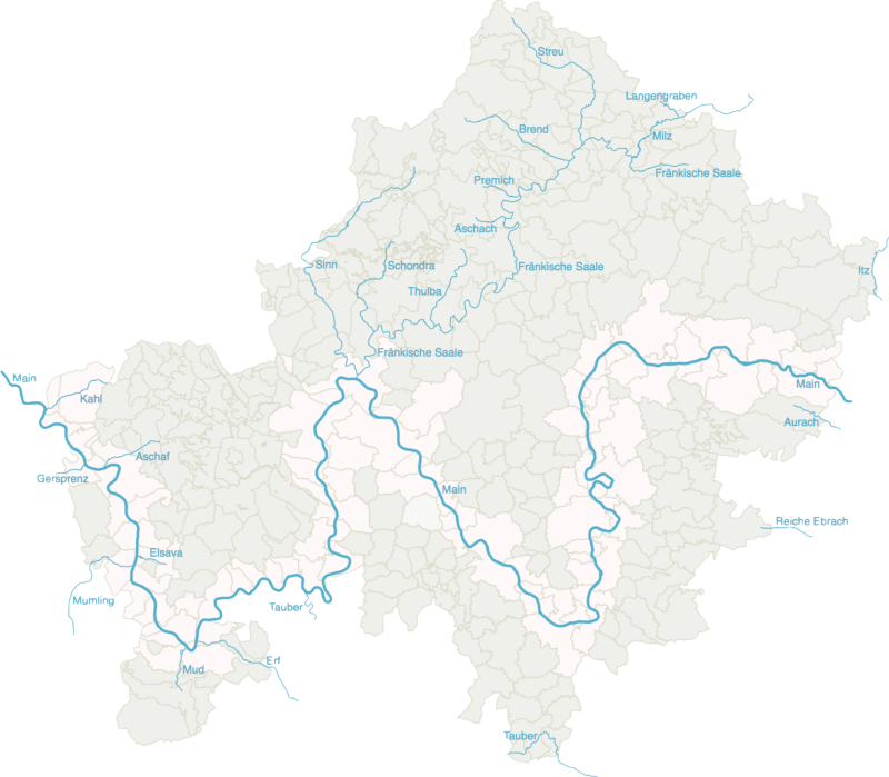
Bad Kissingen is one of many communities in the Lower Franconia region (Unterfranken in German). Like many of its neighbors, a river runs through it: the Fränkische Saale. The boundary of the community forms a single shape; it maps to the Polygon geometry type. The water courses that make up the river can be imagined as a series of lines joined together. They map to the MultiLineString type.
I’ve found some maps of Lower Franconia online. I can process all the region’s rivers and communities into NDJSON (newline delimited — another variation of JSON). I create an Elasticsearch index, and load the data into it. Now I’m ready to search. Gut, wir machen einen Test!
Searching for rivers
A simple term query tells me that there are 22 rivers and 360 communities in Lower Franconia. There are many more water courses in the downloaded data, but only 22 are defined as rivers. Time to try some more complex queries. I’ll begin with the region’s principal river, the river Main, which sounds like Mine in German. I wonder how many communities it flows through? The query I send to my index looks like this:
GET lower_franconia/default/_search{ "query": { "bool": { "filter": [ { "term": { "feature": "community" } }, { "geo_shape": { "geometry": { "indexed_shape": { "index": "lower_franconia", "type": "default", "id": "12", "path": "geometry" }, "relation": "intersects" } } } ] } }}This query is being run in a filter context. This means that relevance scores are not calculated. I'm not concerned with how well things match, but rather whether a match exists or does not. In this context, I specify an array of two items.
In the first item, I am specifying a term key with community features as a constraint. This means that only documents in my index which have a value of community in the feature field will be returned.
In the second item of the array, I have a geo_shape query specifying document number 12 (this document describes the river Main) and a relationship of intersects as the constraints.
Put simply, match all community shapes that intersect with a particular river line.
I get 91 hits. A quarter of all communities are on the Main. The result is formatted in — yes you guessed it — JSON. Although JSON is quite readable, it’s not easy to understand at a glance. Better to create a data visualization with d3.js so that the results can be understood instantly.
For more details about how this is done, see my previous post on web page cartography.
Could a brown bear, a black bear, and a polar bear meet?
Web page cartography can show us wheretowardsdatascience.com
Next up, how many rivers are close by? If I want to stroll by a river this evening, but don’t want to travel, say more than ten kilometers, what are my options?
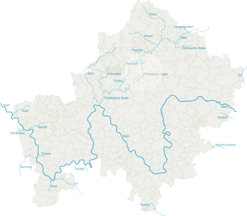
Four hits come back: the rivers Aschach, Fränkische Saale, of course, Thulba, and Premich. This query is slightly different from the previous one. This time I only want rivers to be returned. Also, I am specifying a new shape that does not exist in the index. A circle which is centered on my current location with a radius of ten kilometers.
One more. Where shouldn’t I go if I want to walk by a river? For this query, I use a must_not key to filter out the communities that intersect with any of the 22 rivers. I get 199 hits – just over half of the communities in Lower Franconia are without a river.
Real world application
I have used the rivers and communities of Lower Franconia as a simple example to illustrate how map features can be indexed with Elasticsearch, and the query results visualized with d3.js.
Could it have a practical application? Well, the index could be used, for example, to find out which communities to warn if a flood alert was issued for a particular river. Perhaps it could be used, in a drier region, to predict where droughts might cause problems for agriculture.
Of course, we are not limited to river courses and community boundaries. Any combination of map features can be mapped and indexed and, therefore, there are many possible applications.
Data: OpenStreetMap + Open Data Portal des Freistaats Bayern
Originally published at 24ma13wg.github.io.